-
City Departments
-
- Boards and Committees Budget Committee Planning Commission Public Safety Commission Urban Renewal Agency City Council Agendas & Minutes Public Information Request
- Departments Administration Building 9-1-1 Emergency Communications Center Finance Fire Parks & Recreation Planning Police Public Works
- Community Who Was John Day? John Day Newsletter Lodging Photo Gallery Useful Links
-
- Business & Development
-
Recreation & Events
-
- About Who Was John Day? Community City Newsletter Chamber of Commerce Lodging Photo Gallery Useful Links
- Events and Activities Special Events City Calendar Recreation JDCC Parks & Rec District Park Sites Directory Nearby Recreation
- Library Library Foundation Schools Grant County School District #3 Transportation Grant County Transportation District
-
-
Contact & FAQs
-
- Job Opportunities Alerts and Notifications Email Subscriptions Events and Meetings Agendas and Minutes Calendar
- Contact the City Submit a Request or Concern Staff Directory Social Media Facebook City News
-
Floodplain Map Updates
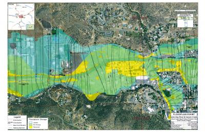
The City of John Day, Grant County and Canyon City are coordinating with the Army Corps of Engineers and the Federal Emergency Management Agency (FEMA) to update our region's floodplain maps.
Floodplain maps are used to guide local jurisdictions during land use planning and also to determine floodplain liability under the National Flood Insurance Program (NFIP) administered by FEMA.
Why are we updating?
The last time our floodplain maps were updated was in 1981. These maps were based on studies of the John Day River and Canyon Creek watershed that were conducted in the late 1970's. The maps produced from these studies were hand-drawn as opposed to digital maps. Over time, the watershed's course and flow rates have altered. The Army Corps of Engineers also has better technology at its disposal to map the real risk of flooding to our community. Finally, FEMA began a multiyear Flood Map Modernization (Map Mod) program as part of a Presidential initiative funded by Congress to update the nation’s flood maps and provide digital Flood Insurance Rate Maps (FIRMs). As a result of these changes, the floodplain maps for our community need to be updated.
What is the timeline?
The entire process is expected to take approximately 18 months to complete. The Corps submitted its data to FEMA in January 2017. FEMA will conduct a:
- 30-day Content Review
- 90-day Technical Review
- 30-day Mapping Panel Review
At the conclusion of the review period, FEMA will generate preliminary floodplain maps. Two public notifications will be provided and we will hold a community meeting to discuss the proposed map changes. Following these events, FEMA will have a:
- 90-day Appeal Period
- Final Approval (upon adjudication of appeals)
- 6-months after approval, the floodplain maps will become official
How will it affect me?
The biggest impact to property owners is on NFIP insurance rates. If you currently pay for flood insurance because your property is in the floodplain, you may continue to be in the floodplain or you may be removed based on the updated data. Similarly, property owners in areas adjacent to the current floodplain may become part of the new floodplain map. The changes will also impact the City's Development Code regulations within the floodplain.
Where can I get more information?
A copy of the December 2014 Flood Study conducted by the Army Corps of Engineers is available for review at City Hall and digital versions of the proposed changes to the floodplain and floodway are below.
